

Altaf Hamid Rao,
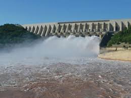
Water rose to the level of 1215.20 feet against the maximum of 1242 feet,
MIRPUR (AJK): The country’s second largest reservoir – the Mangla Dam reached its maximum conservation level as it attained the level of 1215.20 feet above mean sea level on Wednesday, official sources said.
As a result of torrential rains besides swift melting of snow on the snow-clad upper reaches of the Himalayan Jammu & Kashmir State, Water level in country’s second largest Mirpur AJK-based Mangla dam is swiftly rising as water level is swiftly getting close to its climax, the official sources told this Correspondent here on Wednesday.
The water level in the reservoir was recorded as 1215.20 feet against maximum conservation level of 1242 feet with live storage of 5.346 MAF on Wednesday.
The minimum operating water level in the dam is 1050 feet.
The inflows of water of Jhelum river at Mangla was reported 34600 cusecs with the outflows of 10000 cusecs from the Mangla reservoir on Wednesday, the sources said.
The overall position of the river inflows and outflows at Tarbela, Mangla and Chashma along with the reservoirs levels and the barrages remained on Wednesday as under:
Rivers: Indus at Tarbela: Inflows 183000 cusecs and Outflows 182700 cusecs, Kabul at Nowshera: Inflows 39500 cusecs and Outflows 39500 cusecs, Jhelum at Mangla: Inflows 34600 cusecs and Outflows 10000 cusecs, Chenab at Marala: Inflows 77300 cusecs and Outflows 59700 cusecs.
Barrages: Jinnah: Inflows 228100 cusecs and Outflows 220100 cusecs, Chashma: Inflows: 224500 cusecs and Outflows 170000 cusecs, Taunsa: Inflows 273400 cusecs and Outflows 263200 cusecs, Panjnad: Inflows 64100 cusecs and Outflows 48300 cusecs, Guddu: Inflows 422700 cusecs and Outflows 386000 cusecs, Sukkur: Inflows 363900 cusecs and Outflows 303600 cusecs, Kotri: Inflows 182600 cusecs and Outflows 146500
Reservoirs (Level and Storage):
Tarbela: Minimum operating level 1392 feet, present level 1550.00 feet, maximum conservation level 1550 feet, live storage today 6.049 million acre feet (MAF).
Mangla: Minimum operating level 1050 feet, present level 1215.20 feet, maximum conservation level 1242 feet, live storage today 5.346 MAF.
Chashma: Minimum operating level 638.15 feet, present level 645.70 feet, maximum conservation level 649 feet, live storage today 0.145 MAF.
The inflows and outflows of River Indus at Tarbela and Chashma, River Kabul at Nowshera and River Jhelum at Mangla have been reflected as mean flows of 24 hours, whereas the other flows have been gauged at 6.00 a.m on Wednesday


